- Thumbnail
- Resource ID
- 6b255b90-6f6a-11e9-8d7d-000d3ab6a624
- Title
- TM-BRB_Benthic Habitat (South and East Coast)-1998-1:5000
- Date
- May 5, 2019, 2:17 p.m., Publication
- Abstract
- Surveys of the marine habitats along the South-East,East and North-West coasts of Barbados from inter tidal zone to the 50 metre depth contour. Using walkover , scuba diving and snorkel survey techniques.The extents were from Maycocks Bay, between Harrison Point and Arawak Cement plant to South Point . This data was provided by in August 1998.
- Edition
- --
- Owner
- gridanode
- Point of Contact
- devrsgis@gmail.com
- Purpose
- --
- Maintenance Frequency
- None
- Type
- not filled
- Restrictions
- None
- None
- License
- None
- Language
- eng
- Temporal Extent
- Start
- --
- End
- --
- Supplemental Information
- No information provided
- Data Quality
- --
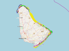
- Extent
-
- long min: -59.6657459983
- long max: -59.3951129381
- lat min: 13.0250773426
- lat max: 13.3502552479
- Spatial Reference System Identifier
- EPSG:900913
- Keywords
- no keywords
- Category
- None